The concept of nature lies in its structure of processes, organisms keep an homeostatic balance in response to the continuous changes in the environment, a non-linear network where everyone interacts with everyone else, all at the same time. The basis of these processes is the control over the information flow, exchange and interplay among the organisms and between them and their environment. Adaption and self-regulation happen perpetually during the life cycle, while environmental pressure cause a selection in populations that produce an evolution in future generations.
In order to approach an architectural design that goes beyond the static definition of sustainability and engages a more natural relation with the environment in order to create a synthetic ecology (synthetic is used to indicate what is built and differentiate it from what naturally grows; the concept of “artificial” as opposed to “natural” is a mind abstraction, synthetic is not synonymous of artificial), the starting point is to build a pervasive information model of the environment. Environment is here intended not only under its physical intensive data (temperature, wind, solar radiation absorption, …) but as the set of conditions and pressures (physical, cultural, social, ediphic) that influence the habitat and architectural performative behaviors at different scales (macro and micro).
From punctual survey or simulation via specific software, the collected information is then extrapolated to continuous data fields throughout the considered area and its related surroundings.
Architecture then will be studied as the open result of the modulated response to these environmental conditions at different scales. Open design strategies will be applied in a process of selection over a population of options in order to pursue a wide range of student’s chosen specific efficient design. Final results, depending on the chosen strategy for the project, will be closer or farther to the actual architectural, building and production system, thus hopefully depicting a gradient of opportunities.
Aim of the course therefore is not scrutinize a specific and strict range of conditions but to introduce students to a design process through population and selection, where, just like in nature, forms find their possible functions. More to that extent, project will engage and negotiate their relation with the territory in order to produce architectural outcomes as much as possible compromised with reality.


_ Alessio
Showing posts with label project. Show all posts

22.3.10

: : Th. final thesis projects 03


Giacomo Damiani did a very accurate analysis of thigmotropism and intertwining of vines. This natural strategy was then translated into a design opportunity for park infrastrucutres which take advantage of tubular structures to become environmental intensifiers. His work is a thesis work in Architectural design at the Faculty of Engineering, Università di Bologna, advisor: Alessio Erioli.

Check his thesis work on his
blog (in italian).

19.5.09

: : 02. strategies

Practice without theory is Blind. Theory without practice is Sterile.

Confucius
[quoted from Cristiano Ceccato paper at Id&cT, Milan, May 6th, 2009]


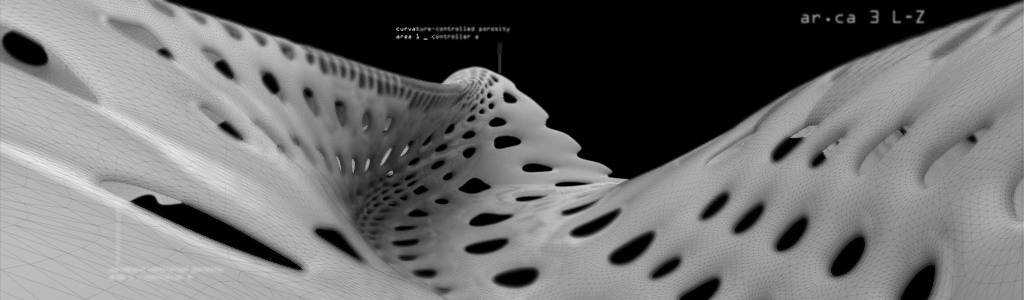
Starting from the study of a biologic organism in the field of botany, the student should identify one or more morphogenetic processes that would relate form generation and differentiation (with the implication of space formation and distribution, structural and material performance) in response to the variation of an external stimulus. Those processes must then be translated into architectural conditions (a less potential version of a body plan mentioned by Deleuze) in order to explore differentiation, articulation and modulation and its potential performative outcomes.
Subsequentially the proliferation (integrated with ground and edge negotiation rules) of the system on the territory will function both as a first masterplan strategy for program integration and a test model for emergent system properties due to part-to-whole and whole-to-part relationship.
Following here is a gallery containing an excerpt of pictures from the LaB work in progress of the students in march-april 2009.


:: The WIP gallery slideshow:


The project shown are from the following students:

Michele Semeghini, Alessandro Mazzette, Andrea Romano, Chiara Salvadori, Davide Sartini, Eufemia Papacharissis, Francesca Papi, Corrado Giacobazzi, Valentina Laghi, Luca Nazzari, Leandro Robutti, Matteo Tosi, Stefano Coccia, Simone Righi.

Here's a few samples (see larger images from the gallery linked above):


Michele Semeghini


Matteo Tosi


Luca Nazzari


Chiara Salvadori


Davide Sartini


Corrado Giacobazzi

20.2.09

: : 01. diagrams

“Let us go back to the map and the territory and ask: "What is it in the territory that gets onto the map?" We know the territory does not get onto the map. That is the central point about which we here are all agreed. Now, if the territory were uniform, nothing would get onto the map except its boundaries, which are the points at which it ceases to be uniform against some large matrix. What gets onto the map, in fact, is difference, be it a difference in altitude, a difference in vegetation, a difference in population structure, difference in surface, or whatever. Differences are the things that get onto a map.

But what is a difference? A difference is a very peculiar and obscure concept. It is certainly not a thing or an event. This piece of paper is different from the wood of this lectern. There are many differences between them—of color, texture, shape, etc. But if we start to ask about the localization of those differences, we get into trouble. Obviously the difference between the paper and the wood is not in the paper; it is obviously not in the wood; it is obviously not in the space between them, and it is obviously not in the time between them. (Difference which occurs across time is what we call "change.")

A difference, then, is an abstract matter.”

Gregory Bateson, Form Substance and Difference, from Steps to an Ecology of Mind, 1972

“Writing on information theory, Gregory Bateson defines a map itself not as a territory but as the establishment of difference that defines territories. The diagram, when used properly and productively, behaves in a similar way, as an abstract gradient defining a range of difference. Like the projection of various systems of content onto the same map, there is a potential in “the difference that makes a difference”. This difference is not automatically produced as an inherent feature of the map but is the result of value judgments.”

Reiser+Umemoto, Atlas of Novel Tectonics, Princeton Architectural press, ch.54

After a period spent collecting and sharing data among themselves, students individually began to select, sort and organize them in order to produce what is intended above in the definition of diagram: a gradient field of intensive forces operating on the territory. Diagrams will be used throughout the whole lab period as an operating tool in the definition of projects, according to a multiplicity of approaches.

Here below are some examples of how students formulated their diagrams.

Michele Semeghini (ST, vegetation mass & wind):


Matteo Tosi (PC, vegetation species network & CO2 absorption):


Leandro Robutti (ST, photosynthesis & oxigen volumes):


Daria Zacchini (ST, vegetation species network):


Lucia Mondardini (PC, acoustic mapping):


Andrea Romano (PC, acoustic Mapping & direct radiation mapping):

1.1.09

: : 00


Let’s get started! After a long wait the blog starts hosting some results. As a teacher and blogkeeper I think it’s up to me to pull the trigger and fill in the first informations and results about the course, its aim and purpose and a synthesis of selected works so far. Comments and critics from readers are highly welcome (please be constructive and play fair).

. synopsis

The concept of nature lies in its structure of processes, organisms keep an homeostatic balance in response to the continuous changes in the environment, a non-linear network where everyone interacts with everyone else, all at the same time. The basis of these processes is the control over the information flow, exchange and interplay among the organisms and between them and their environment. Adaption and self-regulation happen perpetually during the life cycle, while environmental pressure cause a selection in populations that produce an evolution in future generations.
In order to approach an architectural design that goes beyond the static definition of sustainability and engages a more natural relation with the environment in order to create a synthetic ecology (synthetic is used to indicate what is built and differentiate it from what naturally grows; the concept of “artificial” as opposed to “natural” is a mind abstraction, synthetic is not synonymous of artificial), the s
tarting point is to build a pervasive information model of the environment. Environment is here intended not only under its physical intensive data (temperature, wind, solar radiation absorption, …) but as the set of conditions and pressures (physical, cultural, social, ediphic) that influence the habitat and architectural performative behaviors at different scales (macro and micro).
From punctual survey or simulation via specific software, the collected information is then extrapolated to continuous data fields throughout the considered area and its related su
rroundings.
Architecture then will be studied as the open result of the modulated response to these environmental conditions at different scales. Open design strategies will be applied in a process of selection over a population of options in order to pursue a wide range of student’s chosen specific efficient design. Final results, depending on the chosen strategy for the project, will be closer or farther to the actual architectural, building and production system, thus hopefully depicting a gradient of opportunities.
Aim of the course therefore is not scrutinize a specific and strict range of conditions but to introduce students to a design process through population and selection, where, just like in nature, forms find their possible functions. More to that extent, project will engage and negotiate their relation w
ith the territory in order to produce architectural outcomes as much as possible compromised with reality.

Alessio Erioli

. sites

Following a line that has produced consistent results over the past years, project sites are discussed with local municipalities or institutions in order to find places of common interest where students contribute with fresh ideas to the architectural debate, actively engaging a bilateral relation with the city.

Thanks to the collaboration with Arch. Francesco Evangelisti from the Municipality of Bologna, this year two particularly interesting sites were chosen for their intrinsic urban complexity and environmental critic situation. Both sites, located in the urban belt of Bologna, relate with heavy traffic routes, green areas and urban void. Both should host mixed use urban facilities, relate with green and solve traffic flow (cars, pedestrian, bikes, metro, …).


. Site 01 _ Prati di Caprara (PC)


A former inhabited area and park, bombed during world war II, inhabited again and then dismissed is now a 300 meters void along one of the main linking routes of Bologna (via Saffi, the west side of the roman decumano, the part of via Emilia that leads to Modena). The future Metrotramvia will have one of its stop along the area facing via Saffi. Here public facilities (plus some housing that will not be treated in depth in the course’s projects) and strong integration between building and vegetation are required. The amount and kind of facilities implemented may vary according to the data interpretation and the emergent characters of the related project. While the road front and the two sides are to be considered as explicit fixed limits, the depth of interaction among project and site is up to the single student.


. Site 02 _ Stalingrado (ST)


Highway nodes are characterized by the presence of ramps, which necessity of minimum curvature radius usually cuts away “petals” of territory that are normally unused due to traffic related problems (such as noise and pollution). In this case, despite the highway is splitting the territory perpendicular to the N-S direction, the four petals are strategically placed at the intersection of the areas of influence of the Bologna fair, a park hosting events and venues (Parco Nord) and a forthcoming tech hub for collaborations between university and enterprises (located in the former tobacco manufacturing building). This is the chance to design multi-performative spaces for events (cultural, business and leisure-related) and daily use that will also support a stronger north-south pedestrian and bike connection.

calendar